

Deze site maakt gebruik van cookies, zodat wij je de best mogelijke gebruikerservaring kunnen bieden. Cookie-informatie wordt opgeslagen in je browser en voert functies uit zoals het herkennen wanneer je terugkeert naar onze site en helpt ons team om te begrijpen welke delen van de site je het meest interessant en nuttig vindt.
FAQ for Windplanner usage
Camera advice
Which camera should I use to take the panorama photos
We recommend one of the following equipment/methods for taking the 360° panoramic photos.
- The first advice is to use matterport (one easy click and really good quality), but this is a quite expensive method.
- The second advice is camera+fisheye+rotator+ptgu
i stitching. This one is more complex than the first advice but will be less expensive.
- The third advice to have the insta 360 nano. This is the cheapest, easiest option but has moderate quality.
3D & Performance
How to enable the dedicated GPU in laptops
Laptops with dedicated graphics processors (GPU’s, mostly from Nvidia) require a settings-change. To save energy, the GPU is disabled while browsing the web. To enable the high-performance video chip for use in Windplanner, go to the Nvidia control panel (through the Windows task bar or Windows control panel) and add your browser to the power-save exceptions. Optionally, see “how to enable Harde Acceleration in Google Chrome”. There are too many hardware- and browser-specific combinations to explain, so kindly refer to your favorite search engine or ask our support staff.
How to enable Hardware Acceleration in Google Chrome
To enable the graphics hardware acceleration in Google’s Chrome Web browser, use the following steps:
- Open the Chrome Web browser.
- In the address bar, enter “about:flags” (without the quotes), and then press Enter. A list of experimental features should be displayed.
- Search for “GPU Accelerated Compositing”, and then click the “Enable” link.
- Next, search for “GPU Accelerated Canvas 2D” and click the “Enable” link.
- Close and restart the Chrome Web browser.
Which 3D terrain data is used?
Windplanner consists of a combination of open source data and Cesium world terrain. The resolution is depending on the location in the world:
- England: ~1-2 m
- Australia (populated areas and coasts): 5 m
- New Zealand: 5 m
- USA West Coast: 0,5 m
- USA: 1 – 30 meters
- Europe: 30 meters
- Approx. -60 to 60 degrees latitude: 30 – 90 m
How to use our own DEM and/or satellite images
It is possible to link to different terrain servers. If you host your own height data, please contact Windplanner support. If you do not host your terrain data online but manage it offline, we can import it for you. Please see our Request page.
Which satellite images are used?
Satellite images are supplied by Mapbox, which in turn processes them from the sources below (relative to zoom levels, 19 being closest to the earth). Pixel density depends on many different factors, please consult relevant local sources.
- 13–19: a combination of open and proprietary sources, including DigitalGlobe’s GBM 2011+ for much of the world, USDA’s NAIP 2011–2013 in the contiguous United States, and open aerial imagery from Denmark, Finland, and parts of Germany.
- 9–12: Landsat 5 & 7, 2010–2011
- 0–8: MODIS 2012–2013
For more information, see: mapbox.com/maps/satellite.
If you require more detailed satellite & 3D terrain data, please contact us for a quotation.
Are the turbines displayed correctly in the (StreetView) panoramic photos?
Yes. After you have calibrated the photo, you will have a flawless photomontage. Using spheric photos such as Google StreetView is much more precise than using traditional ‘flat’ photos. This is because spheric photos can be aligned visually across a much wider area. So you can use the typical landmarks in the spheric photo (rotating 360 degrees) to match it perfectly with the 3D world. Also – by playing with the opacity – you can see both the 3D world and the photo. So you get instant feedback on both the position and the rotation of the spheric photo in the 3D world. See also our tutorials.
The Google StreetView panorama looks a bit blurry. Can I adjust the resolution?
Yes, you can increase the resolution, if Google has covered that location recently. Google is gradually replacing its panoramas with higher resolution panoramas.
To adjust the resolution (if available by Google), go to Edit-Settings-Pro settings-StreetView quality-choose quality level.
Be aware that the highest quality level will put quite a demand on your computer capacity. So, pending on your computer, it can impact the loading speed in your Windplanner project.
Note that you can also upload your own panorama photos (or photos made by a photographer), should the quality of the Google StreetView photos not meet your expectations.
Are shadows displayed correctly?
Yes. Because Windplanner uses the scientific Cesium 3D engine, all calculations within Windplanner are mathematically correct. Therefore, shadows are drawn with the correct length and the correct direction depending on the location of the sun.
Compatibility
Which browsers are supported by Windplanner?
Windplanner works on modern (3D WebGL supporting-) web browsers. If some feature does not work as expected, we recommend using Google Chrome, Mozilla Firefox or Microsoft Edge.
A note on Safari: Windplanner does work, but in order to minimize artefacts and maximize performance we recommend a browser with better WebGL support.
A note on the recent Chrome update (12/15/2016): combined with a certain Windows update and older AMD-graphics hardware: a decrease in performance can be noticed. If so, please try another browser or upgrade your computer hardware.
Please see the compatibility chart for more information.
What are the Minimum System Requirements?
Hardware
High-performance, up-to-date computer specs are highly recommended. Windplanner is a forward-thinking application which runs best on a modern PC. Older hardware will work in most cases, but you are more likely to run into limitations.
Microsoft Windows
- Operating System: Microsoft Windows 7
- DirectX version: 11.3
Apple Macintosh
- Operating System: MacOS 10.x
Linux
- Any supported Linux distribution
Thin Clients
- Due to demanding graphics, using Windplanner on a thin client or virtualized desktop will degrade user experience (ask your administrator if 3D graphics are disabled on your thin client). It’s probably best to request a stand-alone laptop if your organisation uses thin clients.
What are the Minimum Requirements for VR-playback?
Windplanner works on mobile phones with fast graphics processors. Currently, the best performance is experienced with recent Samsung smartphones and with any Google Daydream Certified handsets, such as the Google Pixel or the ZTE Axon.
iOS devices do work, but performance is low.
Please log in to app.windplanner.com on your smartphone and press the VR-button.
Why is Windplanner not loading on my device?
Try taking the following steps to determine why Windplanner won’t open, please first take a look at the minimum system requirements:
- Check your browser (check our FAQ: which browser are supported – and we like to use Chrome)
- Turn your browser off/on and try again
- Update your current browser, when there is an update available
- Check your internet connection speed
- Disable low power mode
- Enable GPU (check our FAQ: how to enable the dedicated GPU in laptops)
- Try to run Windplanner on another laptop or PC
How to
How to log in
- Go to app.windplanner.com
- Enter your e-mail address
- Enter your password
- Click the arrow to log in
How to navigate the 3D world
- Use the left mouse button to look around in 3D
- Right button moves the camera right, left, back- and forward
- Press the scroll button and drag to rotate around wind turbines
How to create a new project
- Log in on app.windplanner.com
- Click on “Create project” button at home screen
- If placing turbines by hand: click on Edit, Search to choose your location, Turbines, Place turbines, click on the 2D map and see the turbine in the 3D world. Click on Visualize, StreetView tool, click anywhere on the blue lines in the 2D world, and you enter the Panoramic photo in the 3D world.
- If placing turbines: click on Edit, scroll down in the white column to New turbines, click on +, and choose whether you want to import a file, or to copy-paste at ‘create at coordinates’. Make sure you have your coordinates separated by a comma, and that you have chosen the right coordinate system!
How to change transparency of layers
Open the Layer window.
Each active layer has a slider on it, to configure transparency. You can change the transparency of a layer by moving the slider.
To move the slider you need to:
- Place your mouse cursor on slider of the layer you wish to change transparency settings
- Hold your left mouse button
- Move the grip to left to make it transparent or move it to right to make it opaque/less transparent
How to upload spherical panoramas
How to im- and export turbine layouts
- To import turbine coordinates: Click on Edit, Turbines, scroll down in the white column to New turbines, click on +, and choose whether you want to import a file, or to copy-paste at ‘create at coordinates’. Make sure you have your coordinates separated by a comma, and that you have chosen the right coordinate system!
- To export turbine coordinates: Click on Edit, Turbines, Layouts, Select the layout that you want to export, click on Export turbines to CSV (this is a comma separated values – file).
How to share my projects
- Select a project at the Dashboard
- Click on “Share” button
- Enter e-mail address of the person you want to invite
- Select user role * (team member, project member or observer)
- Click on “Send invite” button
Note:
- Team members: can see and edit all projects
- Project members: can see and edit one project
- Observers are only allowed to see one project
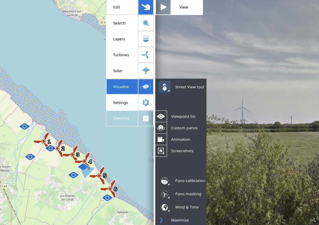
How to enter a streetview panorama
With Windplanner you can see your turbines with streetview images. Below you can see how to use the streetview tool. If you click on the streetview tool button, you will see blue lines appearing on your 2D map. If you click on the blue line you will enter a streetview panorama.
How to see the project in VR
- Open Windplanner on a smartphone (Android works better than iPhone)
- Click on the VR logo at the left top of the screen.
- Put the phone in a VR-viewer.
- The best way to show the project in VR is to create viewpoints on your desktop. You can guide the person with the VR glasses to see all viewpoints. To do this, go to Edit-Visualize-Viewpoints-Click on a viewpoint-Click on ‘summon all clients.
Map Layers
Which layers are currently available?
Currently available GIS* layers are:
- Open Street Maps – a wiki (community populated) world map platform
- Open Sea Maps – Nautical map
- Open Topo Maps – Height map showing terrain elevation
- Thunderforest Landscape – Natural landmarks & forrest and wildlife reserves map
- China Satellite Imagery – Asia originated satellite data
- WindAtlas – Average wind speeds measured at 50m, 100m, 200m
* A geographic information system (or GIS) is a system designed to capture, store, manipulate, analyse, manage, and present spatial or geographical data.
source: https://en.wikipedia.org/wiki/Geographic_information_system
Why is Street View not available at my location?
Street View images are not available everywhere. Some places are limited or unsupported by Google Street View. See coverage of Google Street View at:
https://en.wikipedia.org/wiki/Coverage_of_Google_Street_View
Note: You can upload your own spherical panoramas to Windplanner.
Can I request/add additional layers?
- Yes, it is possible to add your own layers. Click on Edit, Layers, New custom layer, and fill in the elements.
- It’s also possible to link to external map providers. If your organization hosts map data online, there’s a good chance it can be linked.
To request additional layers please contact us by email: info@windplanner.com
Billing & pricing
How to upgrade my trial account?
We will send you a upgrade email about 5 days before your trial version is due to expire. Follow the instructions (which are defined in the mail) to upgrade.
How to change subscription plan?
You can change the subscription plan by phone or email.
To change the subscription plan, please call: +31 (0)515-439230 or send us an email: info@windplanner.com
More information about subscription plans, click here
How to cancel my account?
You can cancel your account by phone or email.
To cancel your account, please call: +31 (0)515-439230 or send us an email: info@windplanner.com
Note: Subscription period is for a minimum of 3 months, after which it can be canceled monthly before the new billing time. For example: if we charge you on on April 9th, and you cancel your account on April 12th, you are still required to pay for the entire month. No subsequent charges are applied, but the amounts already charged are not refunded.
Which payment methods are accepted?
You can pay your Windplanner-subscription by invoice.
Why Windplanner?
10 reasons to use Windplanner?
- To scout the best location, with the help of geographic data layers
- To shape your plan, using the 2D sketching tool
- To get in touch with stakeholders, at any stage of the project
- To make adjustments yourself during the project
- To create alternative layouts and consult with stakeholders for the best option
- To easily collaborate with colleagues and co-creators
- To get realistic and accurate visualizations in the most cost-effective way
- To present your visualizations in different ways
- To speed up your project and convince stakeholders
- To use visualizations from idea to realization
For more information, see 10 reasons why
In which phases should I use Windplanner?
Windplanner is both a sketching tool for the first reconnaissance phase and a visualization tool to enhance stakeholder dialogue.
Privacy & Security
Is my privacy protected?
We take privacy and security very seriously. Your data is encrypted with the most secure encryption methods (which are constantly updated to the newest industry standards).
More information about Privacy & Security.
Features
What features are upcoming?
Windplanner is constantly being updated. Please see the Production Roadmap and the voting form on the features page .