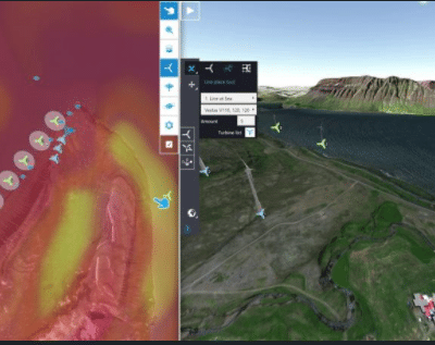
Sketching your windfarm on a 2D map… and get a 3D presentation, right away.
Imagine you are sketching on a 2D map… You measure the distances, so you are sure the turbines are not too close to residential areas, you know the turbines have the correct radius, and you clearly see any potential obstructions on the map.
You choose a location for your wind farm and: you see straight away what it looks like in 3D and Street View. And you can look at it from different angles.
And the good thing is. You can make high-resolution prints, show the plan on a touch screen, see the plan from different angles, make a video and share it on -for instance- Facebook and Youtube. The choice is yours. You can even see it in VR.
If you’d ask an agency to create this for you, you easily spend thousands of euros per project.
With Windplanner you can do it yourself.
In this 2 minute explanation, you can see how.
And if you have any quentions Tedde Langhout is there to help you out.